


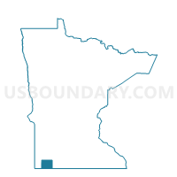
Dundee Voting District, Nobles County, Minnesota
About
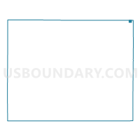
Outline

Summary
| Unique Area Identifier | 603336 |
| Name | Dundee Voting District |
| County | Nobles County |
| State | Minnesota |
| Area (square miles) | 0.31 |
| Land Area (square miles) | 0.31 |
| Water Area (square miles) | 0.00 |
| % of Land Area | 100.00 |
| % of Water Area | 0.00 |
| Latitude of the Internal Point | 43.84411550 |
| Longtitude of the Internal Point | -95.46677460 |
Maps

Graphs
Select a template below for downloading or customizing gragh for Dundee Voting District, Nobles County, Minnesota


Neighbors
Neighoring Voting District (by Name) Neighboring Voting District on the Map
- Belfast Twp. Voting District, Murray County, MN
- Graham Lakes Twp. Voting District, Nobles County, MN
- Southbrook Twp. Voting District, Cottonwood County, MN
Top 10 Neighboring County Subdivision (by Population) Neighboring County Subdivision on the Map
- Graham Lakes township, Nobles County, MN (218)
- Belfast township, Murray County, MN (192)
- Southbrook township, Cottonwood County, MN (79)
- Dundee city, Nobles County, MN (68)
Top 10 Neighboring Place (by Population) Neighboring Place on the Map
Top 10 Neighboring Unified School District (by Population) Neighboring Unified School District on the Map
Top 10 Neighboring State Legislative District Lower Chamber (by Population) Neighboring State Legislative District Lower Chamber on the Map
Top 10 Neighboring State Legislative District Upper Chamber (by Population) Neighboring State Legislative District Upper Chamber on the Map
Top 10 Neighboring 111th Congressional District (by Population) Neighboring 111th Congressional District on the Map
Top 10 Neighboring Census Tract (by Population) Neighboring Census Tract on the Map
- Census Tract 9003, Murray County, MN (3,360)
- Census Tract 2703, Cottonwood County, MN (3,220)
- Census Tract 1051, Nobles County, MN (2,889)